Gallows Campground: Secluded 4WD Riverside Camping in Howqua Hills
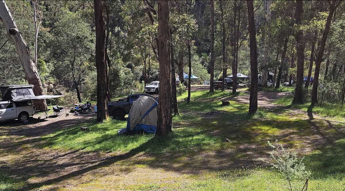
For those seeking a more secluded and adventurous High Country escape, Gallows Campground in the Howqua Hills Historic Area is an exceptional choice. Located just a short drive from the popular Sheepyard Flat, this free campground offers a more rugged and intimate experience on the beautiful banks of the Howqua River. The journey in sets the tone, with a narrower and steeper access track that is best suited to 4WD vehicles and off-road camper trailers, ensuring a quieter and less crowded atmosphere than its more accessible neighbours. The campground itself is a stunning, grassy flat nestled in a valley, surrounded by steep, forested hills that amplify the sense of being deep within the Victorian wilderness.
Like other sites in the historic area, Gallows Flat is steeped in the legacy of mountain cattlemen and gold prospectors. It serves as a fantastic base for exploring the challenging 4WD tracks that crisscross the region, including the Gallows Track which departs directly from the campground. The clear, cool waters of the Howqua River are perfect for a summer swim, and the area is renowned for its excellent trout fishing. The campground is pet-friendly, making it a perfect destination for adventurous campers and their dogs. Facilities are basic, with non-flushing toilets and fire pits provided, so campers must be fully self-sufficient with drinking water and take all rubbish home. For a true High Country adventure that combines stunning scenery, rich history, and thrilling 4WD touring, Gallows Campground is a top-tier destination.
Campground Information
- Name: Gallows Campground
- Address: Gallows Track, Howqua Hills Historic Area, Victoria 3723, Australia
- GPS Coordinates: -37.289074830464884, 146.221657291785
- Website: Managed by Parks Victoria (no direct website for the campground).
Features & Rules
- Location: Secluded, grassy flat on the Howqua River in the Victorian High Country.
- Site Suitable For: Tents and off-road camper trailers. Not recommended for large caravans due to access.
- Road Access: Unsealed track with steep sections. 4WD is highly recommended.
- Site Surface: Grass and natural earth.
- Camping Permitted: Yes, free camping is permitted. No bookings required.
- Maximum Overnight Stays: Up to 28 days.
- Facilities: Non-flushing toilets and fire pits.
- Potable Water: No. You must bring your own drinking water or treat river water.
- Mobile Phone Coverage: Non-existent.
- Onsite Public Toilets: Yes, basic non-flushing toilets are available.
- Rubbish Bins: No. All rubbish must be taken with you.
- Open Fires: Permitted in provided fire pits, subject to seasonal fire bans.
- Generator Use: Permitted, with consideration for other campers.
- Number of Sites Available: Several undesignated, unpowered sites.
- Essentials to Bring: Drinking water, firewood, rubbish bags, and toilet paper.
- Pet Friendly: Yes, dogs are permitted on a leash.
- Fishing: Excellent trout fishing in the Howqua River.
- Short Walks: Informal walks along the river and access to challenging 4WD tracks.
Local Amenities & Attractions
- Local Pubs:
- Kevington Hotel – approx. 35 km
- Mansfield Hotel (Mansfield) – approx. 45 km
- Delatite Hotel (Mansfield) – approx. 45 km
- Places to Eat:
- A wide range of cafes, bakeries, and restaurants in Mansfield – approx. 45 km
- Local Attractions:
- Howqua River & 4WD Tracks
- Fry’s Hut – approx. 8 km
- Historic town of Jamieson – approx. 25 km
Nearby Parks & Services
- Nearest Caravan Parks:
- Jamieson Caravan Park – approx. 25 km
- Howqua Valley Holiday Park – approx. 35 km
- Mansfield Holiday Park – approx. 45 km
- Nearest Alternate Free Camps:
- Sheepyard Flat Campground – approx. 8 km
- Other flats along the Howqua River (e.g., Frys Flat, Pickerings Flat).
- Nearest Dump Points:
- Mansfield Public Dump Point (near Visitor Information Centre) – approx. 45 km
- Nearest Petrol Station: Mansfield – approx. 45 km.
- Nearest Drinking Water Resupply: Public taps in Mansfield – approx. 45 km.
- Nearest Public Toilets: On-site (basic). Flushing toilets in Jamieson or Mansfield.
Seasonal Weather Forecast
- Summer (Dec-Feb): Warm to hot days with cool mountain nights. Perfect for swimming. Average maximum temperatures in nearby Mansfield are around 28°C.
- Autumn (Mar-May): Mild, sunny days and crisp nights with stunning autumn colours. Average maximums range from 16°C to 25°C.
- Winter (Jun-Aug): Cold, with frosty nights and potential for snow on surrounding peaks. Roads can become slippery or impassable. Average maximums are around 12°C to 14°C.
- Spring (Sep-Nov): Cool and becoming milder. The river can be high from snowmelt. Average maximums range from 16°C to 23°C.