Mt No 3 Hut & Camping Area | Remote Alpine High Country 4WD & Historic Hut
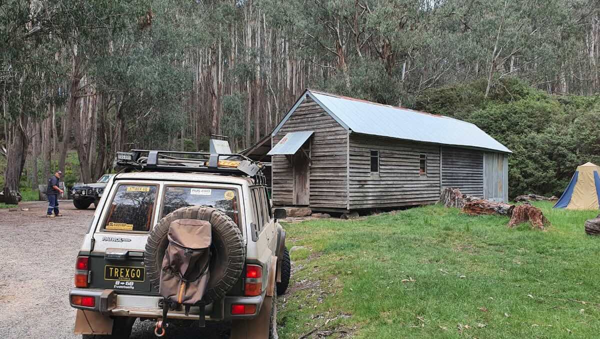
For the ultimate High Country adventure, Mt No 3 Hut stands as an iconic destination, offering a genuinely remote and challenging free camping experience for seasoned four-wheel drivers. This is more than just a campsite; it’s a legendary landmark deep within the Alpine National Park, representing the pinnacle of off-road exploration and self-sufficient bush camping. The journey to the hut is a significant undertaking, requiring a well-equipped, high-clearance 4WD to conquer steep, rocky, and often technical tracks that are strictly for experienced drivers. The reward for this effort is arriving at a magnificent sub-alpine plain, home to the historic cattlemen’s hut and surrounded by breathtaking panoramic views of the Victorian Alps, including the nearby peaks of Mount Buller and Mount Stirling.
The allure of Mt No 3 Hut lies in its profound sense of isolation and its deep connection to the rich history of the mountain cattlemen. The open, grassy area around the hut provides a spectacular setting for tents, swags, and rugged off-road camper trailers. It’s a place to feel on top of the world, where the only sounds are the wind whistling through the snow gums and the calls of alpine wildlife. The area is a central hub for some of Australia’s most famous 4WD and hiking trails, including tracks leading to Craig’s Hut and the Howqua Hills. At night, far removed from any light pollution, the sky explodes into a dazzling display of stars. As a true wilderness camp, it requires complete self-reliance, with no facilities beyond the basic shelter of the hut and a simple toilet. For those prepared to embrace the challenge, a stay at Mt No 3 Hut is a bucket-list achievement, offering an unforgettable adventure into the wild, untamed soul of the High Country.
Campground Information
- Name: Mt No 3 Hut & Camping Area
- Address: Mount Buller VIC 3723
Location Coordinates
- GPS: -37.103929, 146.464096
Website
- Website: This is a free camping area in the Alpine National Park. Information is available on the Parks Victoria website.
Location Map
Site Details
- Location: Remote alpine clearing in the Victorian High Country.
- Site Suitable For: Tents, Swags, and rugged Off-road Camper Trailers only.
- Road Access: Very difficult 4WD tracks only (e.g., via Circuit Road, Clear Hills Track). Extremely steep, rocky, and slippery sections. Full vehicle recovery gear and extensive experience are essential. Tracks are seasonally closed (typically June-November).
- Site Surface: Natural grass and dirt.
- Camping Permitted: Yes, free camping.
- Maximum Overnight Stays: Please observe Parks Victoria guidelines.
- Facilities: Historic hut for shelter, non-flush toilet, fire pit. No other facilities.
- Potable Water: No. You must carry all your own water.
- Mobile Phone Coverage: Non-existent. A satellite phone or personal locator beacon (PLB) is essential.
- TV Reception: Not applicable.
- Onsite Public Toilets: Yes, a single non-flush (pit) toilet.
- Rubbish Bins: No. This is a strict carry-in, carry-out site.
- Open Fires: Permitted in the designated fire pit only, subject to seasonal fire restrictions. BYO firewood from outside the park.
- Generator Use: Permitted, but be considerate of the wilderness values.
- Number of Sites Available: Large, unmarked area.
- Essentials to Bring: PLB/Sat Phone, extra fuel, all water and food, full vehicle recovery gear, shovel, firewood, rubbish bags, own toilet paper.
- Pet Friendly: No. Pets are not permitted in the Alpine National Park.
Activities
- Fishing: Fishing for trout in nearby high country rivers like the Howqua and Delatite.
- Short Walks: This is a premier remote hiking area. The Australian Alps Walking Track is nearby.
- 4WD Touring: The primary activity is exploring the legendary and challenging High Country tracks.
Local Amenities
- Local Pubs:
- The Hunt Club Hotel (Merrijig) – Approx. 40 km
- The Kevington Hotel (Kevington) – Approx. 55 km
- Numerous pubs in Mansfield – Approx. 55 km
- Places to Eat:
- The nearest reliable options are in Mansfield (approx. 55 km) or the Mount Buller Village (seasonal).
- Local Attractions:
- Craig’s Hut – Approx. 15 km (via 4WD track)
- Mount Buller & Mount Stirling – You are between them!
- The Bluff & Razorback Hut – Accessible via 4WD tracks
- Nearest Caravan Parks:
- Mansfield Holiday Park – Approx. 55 km
- Jamieson Caravan Park – Approx. 65 km
- Next Free Camps:
- Numerous other high country huts and clearings (e.g., Razorback Hut, King Billy).
- Howqua Hills camping areas (e.g., Pineapple Flat) – Approx. 25 km
- Nearest Dump Points:
- Mansfield Public Dump Point – Approx. 55 km
- Nearest Petrol Station:
- Mansfield has multiple 24-hour options – Approx. 55 km
- Drinking Water Resupply:
- Available in Mansfield.
- Public Toilets:
- Available onsite (non-flush).
Seasonal Weather Forecast
- Summer (Dec-Feb): Mild to warm days with cold nights. Be prepared for sudden weather changes and storms. Averaging 8-22°C.
- Autumn (Mar-May): Cool, clear days and very cold nights. The prime season for 4WDing. Averaging 3-18°C.
- Winter (Jun-Nov): Very cold, snow-covered, and inaccessible. Roads are seasonally closed.
- Spring (Nov-Dec): Cold to cool as tracks reopen, but can still see snowfalls. Averaging 2-15°C.