Stevensons Falls Campground | Free Otways Forest & Waterfall Camping
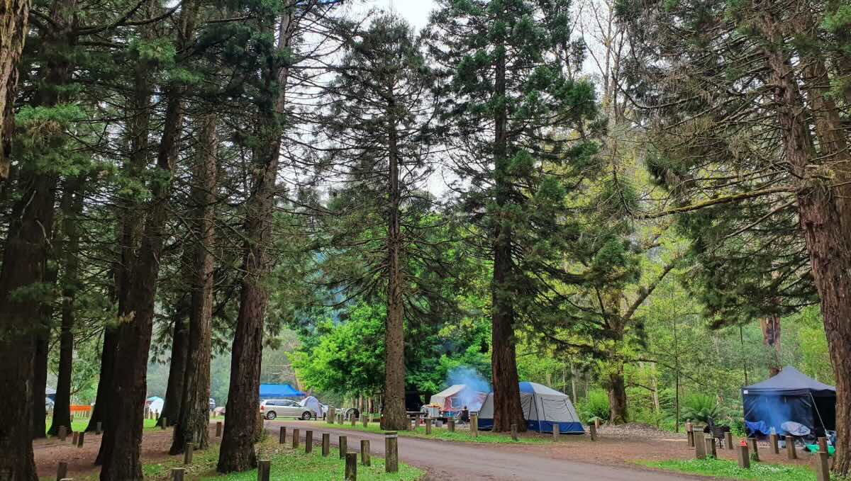
For a truly iconic Otways experience, Stevensons Falls Campground offers a magnificent and spacious free camping area nestled in a beautiful valley alongside the Gellibrand River. This hugely popular destination, located within the Otway Forest Park, is a favourite for families, day-trippers, and travellers seeking an authentic Australian bush camp surrounded by stunning natural beauty. The campground is set in a large, open grassy clearing, surrounded by towering eucalyptus trees and a remarkable stand of giant Californian Redwoods, providing a unique and serene atmosphere. With around 50 designated, unmarked sites, it can accommodate a wide range of setups, from tents and swags to camper trailers and small to medium-sized caravans.
The main drawcard is the majestic Stevensons Falls, accessible via a short and picturesque walk from the campground. The trail follows the Gellibrand River before arriving at a viewing platform at the base of the spectacular terraced waterfall. It’s a fantastic reward for a gentle hike and a perfect spot for photography. The campground itself is an ideal base for relaxation and recreation. The river is a great spot for a paddle or to try your luck fishing for trout, while the large open spaces are perfect for kids to play. Recent upgrades have further enhanced the visitor experience, solidifying its reputation as a top-tier free campground. Its location near the charming town of Forrest, a hub for mountain biking and home to a renowned brewery, adds another layer of appeal. For a memorable and budget-friendly adventure that combines waterfalls, giant trees, and riverside tranquility, Stevensons Falls is one of the Otways’ most cherished destinations.
Campground Information
- Name: Stevensons Falls Campground
- Address: Roadknight Creek Rd, Barramunga VIC 3249
Location Coordinates
- GPS: -38.5639115764225, 143.6562803059073
Website
- Website: This is a free campground in an Otway Forest Park. Information is available on the Explore Outdoors (VIC Gov) website.
Location Map
Site Details
- Location: Riverside forest setting in the Otway Forest Park.
- Site Suitable For: Tents, Camper Trailers, and small to medium Campervans. Not suitable for large caravans or motorhomes due to access road.
- Road Access: Unsealed gravel road (Upper Gellibrand Rd). Generally 2WD accessible but can be narrow, corrugated, and slippery when wet.
- Site Surface: Mostly grass with some dirt areas.
- Camping Permitted: Yes, free camping. No bookings required.
- Maximum Overnight Stays: Please observe FFM Vic guidelines.
- Facilities: Non-flush toilets, shared fire pits, picnic tables. No power or showers.
- Potable Water: No. You must bring all your own drinking water.
- Mobile Phone Coverage: Very poor to non-existent.
- TV Reception: Unlikely.
- Onsite Public Toilets: Yes, non-flush (pit) toilets.
- Rubbish Bins: No. This is a strict carry-in, carry-out site.
- Open Fires: Permitted in designated fire pits only, subject to seasonal fire restrictions. BYO firewood.
- Generator Use: Permitted, but please be considerate of the peaceful environment.
- Number of Sites Available: Approximately 40-50 unmarked sites.
- Essentials to Bring: Drinking water, firewood, rubbish bags, toilet paper, insect repellent, walking shoes.
- Pet Friendly: Yes, pets are welcome on a lead in the Otway Forest Park.
Activities
- Fishing: Fishing for trout and blackfish in the Gellibrand River.
- Short Walks: The main highlight is the walk to the base of Stevensons Falls.
- Mountain Biking: Proximity to the world-class Forrest Mountain Bike Trails.
Local Amenities
- Local Pubs:
- Forrest Brewing Company (Forrest) – Approx. 15 km
- The Terminus Hotel (Forrest) – Approx. 15 km
- Gellibrand River Hotel (Gellibrand) – Approx. 20 km
- Places to Eat:
- Forrest Brewing Company (Restaurant & Brewery) – Approx. 15 km
- Forrest General Store & Cafe – Approx. 15 km
- Local Attractions:
- Stevensons Falls – Onsite
- Californian Redwoods – Approx. 10 km
- Forrest Mountain Bike Trails – Approx. 15 km
- Lake Elizabeth (Platypus spotting) – Approx. 20 km
- Nearest Caravan Parks:
- Forrest Caravan Park – Approx. 15 km
- Dando’s Campground (Free Camp) – Approx. 10 km
- Next Free Camps:
- Dando’s Campground – Approx. 10 km
- Beauchamp Falls Campground – Approx. 20 km
- Nearest Dump Points:
- Colac Public Dump Point – Approx. 35 km
- Nearest Petrol Station:
- Forrest (check operating hours) – Approx. 15 km
- Colac has multiple 24-hour options – Approx. 35 km
- Drinking Water Resupply:
- Available at the Colac Visitor Information Centre.
- Public Toilets:
- Available onsite (non-flush).
Seasonal Weather Forecast
- Summer (Dec-Feb): Mild to warm and can be humid in the forest, averaging 12-25°C.
- Autumn (Mar-May): Cool and calm, often with beautiful misty mornings, averaging 8-20°C.
- Winter (Jun-Aug): Cold and wet, the peak season for flowing waterfalls. Averaging 5-13°C.
- Spring (Sep-Nov): Cool and crisp, with frequent showers bringing the forest to life. Averaging 7-18°C.