The Island Camp Spot, Howes Creek VIC
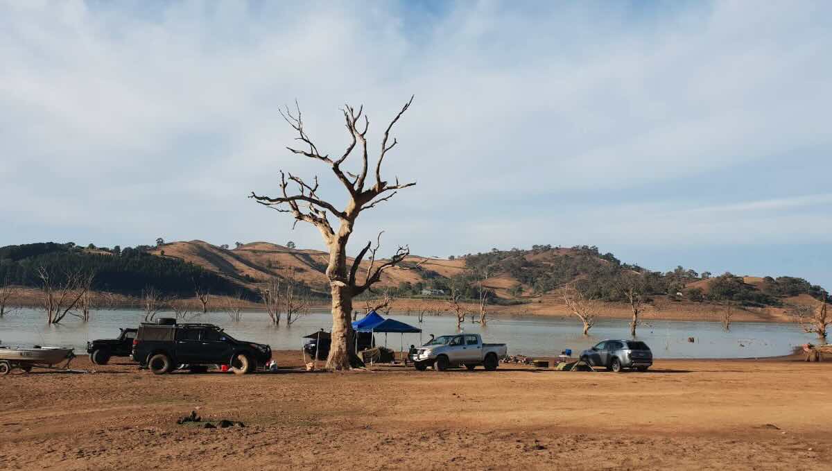
For those in the know, The Island Camp Spot near Howes Creek is a treasured secret—a primitive, secluded peninsula on Lake Eildon that offers an unparalleled sense of isolation and a genuine bush camping experience. This is not a formal campground but an informal clearing in the state forest, accessible primarily by boat or to the most determined 4WD explorers. Its charm lies in its simplicity and its stunning location, which becomes a true island during periods of high water, completely cutting it off from the mainland and creating a private, water-bound sanctuary.
A stay here is about embracing self-sufficiency and the natural environment. The campsite is a rugged, tree-lined clearing that offers spectacular views across the Howes Creek inlet and the main arm of the lake. It’s the perfect place to set up a swag or a tent and disconnect from the world. The days are best spent on or in the water; the sheltered coves are ideal for kayaking, paddleboarding, and fishing for Murray cod and golden perch. The deep water and surrounding drowned timber make for prime angling territory, away from the buzz of the main ski boat areas. As dusk settles, the site comes alive with the sounds of the Australian bush, providing the perfect soundtrack for an evening spent around a campfire under a vast, starry sky.
This is a completely undeveloped campsite. There are no facilities of any kind—no toilets, no water, no bins. Visitors must be meticulously prepared, bringing in everything they need and committing to a rigorous ‘leave no trace’ ethic to preserve its wild, untouched character. A portable toilet is essential. The journey from the public boat ramps at Howes Creek or Bonnie Doon is an adventure in itself, building anticipation for the solitude that awaits. For the prepared camper who values wilderness over amenities, The Island Camp Spot is one of Lake Eildon’s most rewarding destinations.
Location: The Island Camp Spot (Informal Site)
Howes Creek, VIC 3723
Australia
GPS Coordinates: -37.12213802248387, 145.9634802204596
Location Map
Campsite Information
- Location: A remote peninsula near the Howes Creek Inlet on Lake Eildon.
- Site Suitable For: Tents and swags only.
- Road Access: Very difficult and unreliable 4WD access. Primarily a boat-access campsite from Howes Creek or Bonnie Doon ramps.
- Site Surface: Dirt, rock, and natural bush floor.
- Camping Permitted: Yes, free, dispersed camping is permitted in the state forest.
- Maximum Overnight Stays: No specified limit.
- Facilities: Absolutely none. This is a primitive wilderness site.
- Potable Water: No. Bring all required drinking and washing water.
- Mobile Phone Coverage: None. An emergency communication device (PLB or satellite phone) is essential for safety.
- TV Reception: None.
- Onsite Public Toilets: No. A portable toilet and a system to carry out all waste are mandatory.
- Rubbish Bins: No. A strict carry-in, carry-out policy applies.
- Open Fires: Permitted subject to all fire regulations and Total Fire Bans. Use extreme caution.
- Generator Use: Strongly discouraged to maintain the peaceful atmosphere.
- Number of Sites Available: Very limited. A few small, informal clearings suitable for camping.
- Essentials to Bring: All water and food, portable toilet, rubbish bags, emergency communication device, first-aid kit, navigation tools.
- Pet Friendly: Yes, dogs are permitted on-leash as it is within a state forest.
Local Area & Amenities (Distances from Bonnie Doon)
- Fishing: Excellent, isolated fishing for Murray cod, golden perch, and trout. A Victorian Fishing Licence is required.
- Short Walks: Explore the shoreline of the peninsula.
- Nearest Town for Supplies: Bonnie Doon (~15 km by water/road) or Mansfield (~30 km).
- Local Pubs:
- Bonnie Doon Hotel: ~15 km
- The Mansfield Hotel (Mansfield): ~30 km
- The Delatite Hotel (Mansfield): ~30 km
- Places to Eat:
- Bonnie Doon Hotel and local cafes: ~15 km
- Wide range of bakeries, cafes, and restaurants in Mansfield: ~30 km
- Local Attractions:
- The famous Bonnie Doon Bridge.
- The Great Victorian Rail Trail.
- The regional hub of Mansfield.
- Nearest Caravan Parks:
- Lake Eildon Campground (Bonnie Doon).
- Mansfield has several caravan parks.
- Next Free Camps: Other informal sites in the surrounding State Forest.
- Nearest Dump Points:
- Mansfield Showgrounds (public dump point).
- Nearest Petrol Station: Bonnie Doon or Mansfield.
- Drinking Water Resupply: Fill up all water supplies in Bonnie Doon or Mansfield before launching your boat.
- Public Toilets: Located at public boat ramps in Howes Creek and Bonnie Doon.
Seasonal Weather Forecast
- Summer (Dec-Feb): Hot and dry, perfect for water activities. High fire danger. Average temperatures: 15°C to 33°C.
- Autumn (Mar-May): Warm, sunny days and cool nights. Ideal weather for camping and touring. Average temperatures: 8°C to 25°C.
- Winter (Jun-Aug): Cold and often frosty, with occasional rain. Water levels are high. Average temperatures: 2°C to 14°C.
- Spring (Sep-Nov): Mild and pleasant, though weather can be variable. The landscape is green and lush. Average temperatures: 7°C to 22°C.